GET THE UT32 BROCHURE HERE!
The UT56 is very light, with only 750g, it is a great balance between size and comfort. It is equipped with the Android 10 operating system, has an 8-core MediaTek processor that reaches a speed of 2.3 GHz and 4GB of RAM, guarantees good performance in numerous fields of application. The 64GB storage memory can be expanded up to 256GB, thanks to the microSD slot. UT56 is equipped with a USB Type C port which is also OTG, it also has a 7 pin POGO and a 3.5mm audio jack. This device also has two cameras, the one on the back with 13MP, and a slot for nano SIM cards.

GET THE UT56 BROCHURE HERE.
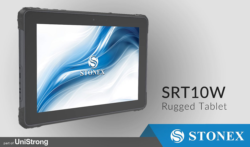
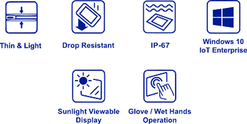
SRT10W is the right choice if you need a very visible tablet because it has a 10.1-inch screen, with an LCD sunlight readable screen, it is also great for working outdoors. Even without additional accessories, this device can be carried for a long time, as it weighs only 750g. The Atom Z8350 Octa-core processor, with a speed up to 1.92GHz is an excellent compromise between good performance and low price. In addition, the SRT10W is equipped with the Windows 10 IoT Enterprise operating system, which is the best choice for both, end-user and embedded use. The input and output ports provided, despite the extremely low thickness are remarkable: two USB ports, an HDMI port and a 7-pin POGO, a microSD slot. The resistance to dust and water is guaranteed by an IP67, and moreover this device is able work at extreme temperatures, or after a 1.2 m (3.9ft) fall impact. SRT10W is the solution for those who work mainly with touch screens, it supports operations with gloves and wet hands, and is equipped with a capacitive multitouch screen, the buttons have been minimized with just the Power and Volume up/down keys. It provides a camera on the front and one on the rear, and its storage memory is 64GB expandable up to 128GB, it is suitable to satisfy tasks with connectivity needs, thanks to the Wi-Fi 802.11a/b/g/n/ac and Bluetooth 4.2.
GET THE BROCHURE HERE.
GET THE BROCHURE
GNSS
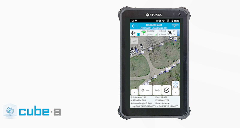
Cube-a is compatible with all Stonex GNSS Receivers. Supports Rover, Rover Stop&Go, Base and Static modes. Various screens provide useful information on the status of the GNSS receiver including the position and the signal quality of the Atlas satellite.
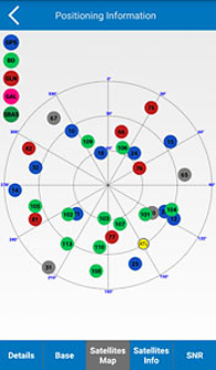
SKY PLOT
Various screens provide useful information on the status of GPS, we also developed the possibility in the Sky Plot to read the presence of Atlas. The innovation to show Atlas correction is in order to help and facilitate the work of surveyors so that, when this correction is needed, they can know if the satellite is seen and in what position.
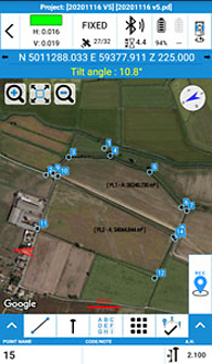
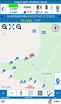
SURVEY
A simple and intuitive survey interface with numerous indicators immediately helps the surveyor to understand what kind of work and in what conditions is taking place. Indicators show various information like solution status, position precision, battery levels, RTK correction delays and more. Intuitive screens allows for an easy change of settings, a view of the collected points, adding new CAD elements and drawings or proceed surveying.
PHOTO & SKETCH
To improve and complete the survey and stakeout functions, you can also use the Photo & Sketch. This function can be used while surveying or even on the already acquired points: take photos and add notes, add and position some indicating arrows or simple hand drawn sketches.
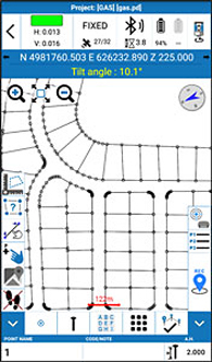
STAKEOUT
A compact interface groups all the stakeout launching commands in one screen for an easier work in the field. Stakeout screens are enriched with both graphical and analytical indicators which guide the surveyor in order to reach the target point. Thanks to this interface, you can read all the information necessary to complete the stakeout work, to select points or to add them and quickly change all settings. Even in case of small monitors, the information and commands are always smartly arranged and readable, the buttons are clickable without difficulty and some of them can be reduced to leave more space for the map.
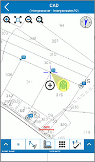
INTEGRATED CAD
Cube-a includes a smart and easy to use CAD feature. The CAD has been designed to work with touch displays and it allows to easily draw points and other CAD entities by mean of a smart pointer which can be moved using one finger and which always transmits to the user a strong confidence of the result achieved. The help of object-snaps like point, mid-point, end-point, intersection and others makes it possible to integrate the survey with new elements directly in the field.
TOTAL STATION
Cube-a has been designed to fully support mixed surveys. A Cube-a survey supports GPS points and classical polar stations and measures at the same time. Polar stations can be set to occupy previously collected GPS points or on unknown positions calculated using the Free Stationing program. Likewise, the GPS reference system can be adjusted to match an existing polar survey in local coordinates. Cube-a supports all Stonex Total Stations via Bluetooth.
GIS
GIS functionalities are well integrated in the workflow of standard GPS surveying. Thanks to the Cube-a’s ability to collect, not only single points but also to automatically draw vectors passing through the collected points, GIS surveying becomes fast and easy. The request to fill in the GIS data is automatic and automatically follows the point or vector acquisition. Data forms can be freely defined using the integrated Feature Set designer or automatically created by Cube-a starting from a sample DBF file.
Import and export of standard shapefiles ensures the compatibility and interoperability of Cube-a with virtually any other GIS software.
3D
The 3D Module adds a complete set of commands to perform Surface Modelling in real-time. Base points and constraints selection is by layer. Optional constraints include a perimeter, break-lines, and holes (non-triangulated closed areas). Surface display mode is selectable from wireframe, filled triangles with edges, shaded triangles with edges, or external perimeter with triangulated points. Volume calculations can be easily defined between a model and a horizontal or inclined reference plane. The results, as well as the surface data, can be exported to different file formats.