|
**TDS Recon**Recon GPS**TDS Terraguide**TDS Locator**Locator GPS**Terraguide GPS**GPS hand held** |
|
|
 |
|
|
|
 |
|
 |
|
|
TDS RECON AS A HANDHELD GPS
|
|
|
|
With the addition of the optional CF cap and Holux GM-270 receiver card, you can turn your Recon into a versatile hand-held GPS unit! The Holux card tracks up to 12 satellites for fast acquisition and re-acquisition. It has a built-in Tracking Loop Processor WAAS/EGNOS Demodulator, and NDGPS/U.S. Coast Guard Beacon support. Other features include low power consumption, built-in rechargeable battery for memory and RTC backup, and enhanced SnapLock and SnapStart algorithms which provide superior navigation performance in urban, canyon, and foliage environments. The CF cap and Holux cards are available separately, or in affordable packages with TDS Locator or TDS TerraGuide. |
|
| TDS TERRAGUIDE GPS PACKAGE |
|
 |
|
|
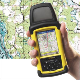
| The TDS TerraGuide navigation package puts digital topographic maps and nautical charts in the palm of your hand, helping you find your way quickly and easily. TerraGuide allows users to determine their location, plan their route, and plot waypoints. The software includes elevation data to display 3-D terrain views, and TerraGuides Quick Chart map engine lets users quickly pan and zoom on maps. You can plot and download waypoints, record a track log, and print full color high resolution charts of your waypoints, routes, and tracks. You can also search a data base of 40,000 places, including mountains, streams, and parks. Optional individual state maps (sold separately) include 1:24,000 scale USGS topo maps, Landsat satellite images and elevation data. |
|
 |
TDS LOCATOR GPS PACKAGE |
|
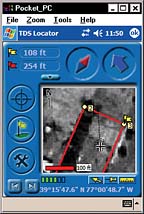
| TDS Locator was designed for professional surveyors, to assist in finding property corners. It is especially helpful for longer boundries and situations where monumentation may be difficult to see. The navigation display shows the route, waypoints, track, north arrow, and target arrow. Points can be entered directly, or imported from an ASCII file. Points can also be entered by azimuths and distances. When receiving a WAAS signal, TDS locator has an accuracy of 2.2 meters. In non-DGPS mode, the accuracy range is from 5 to 25 meters. Locator also has the ability to track the users position on the screen as he is moving across the landscape. JPG background maps (such as aerial photos) may be used with TDS Locator, as shown at left. |
|
| TDS TERRAGUIDE AND LOCATOR PRICING |
|
| TERRAGUIDE with CF cap and Holux GPS card, PC and Recon software, and full-color 1:250,00-scale maps for the continental United States..................................................................list price $299.00
TERRAGUIDE as above, with TDS Recon data collector.....................................................................call!
TERRAGUIDE software (only) for Recon..........................................................................................$119.00
TERRAGUIDE mapsets for individual states; USGS quads at 1:24,000, 1:25,000, 1:100,000 and 1:250, 000 scales; detailed elevation data and gazetteer; Landsat satellite images; USA and World Base-maps (some "smaller" states are bundled together); specify state.......................................$95.00
LOCATOR with CF cap and Holux GPS card, and software........................................list price $299.00
LOCATOR as above, with TDS Recon Data Collector...........................................................................call!
PLEASE CALL (562-426-1306) OR WRITE FOR PRICING AND MORE INFORMATION!
|
|
| LEARN MORE ABOUT LOCATOR FROM TDS
LEARN MORE ABOUT TERRAGUIDE FROM TDS
|
|
|
|
|
|
|
|
|
|
|
|
|
|
|
|
|
|
|
|
|